The lands of Northwestern Lýthia are as diverse as those surrounding the Mediterranean Sea on our own earth. Within this diverse region there are
large tracts of land that are sparsely settled and have little to do with the agricultural pursuits of the civilized lands of Northwestern Lýthia.
Because of this I will first focus on the dominant land types within the region. After that we will look in more detail at the land types where
civilized agriculture will normally be found. Finally I'll address the land types found within the more common civilized agricultural institutions of
the manor and/or villa.
Dominant Land Forms of Northwestern Lýthia
-
Mountain and Alpine Zones
-
Within Northwestern Lýthia, mountainous and alpine regions are a barrier that affects the civilized peoples who live within their shadow.
Hârn itself has four ranges cutting across the island and Northwestern Lýthia is crisscrossed with numerous ranges itself. These ranges are
a vital source of water for the entire region and in some cases provide valuable grazing for the local populations.
-
Per Answers.com
Mountain geomorphology classifies various environmental zones, from lowest to highest altitude. Near the bottom are flood plains,
river terraces, and alluvial fans, all areas heavily affected by rivers flowing from higher elevations. (In fact, many of the
world's greatest rivers flow from mountains, examples being the Himalayan Ganges and Indus rivers in Asia and the Andean Amazon in
South America.) Farming villages may be found as high as the 9,845-ft. to 13,125-ft. range (3,000-4,000 M), an area known as a
submontane, or forested region.
The tree line typically lies at an altitude of 14,765 ft. (4,500 M). Above this point, there is little human activity but plenty of
geologic activity, including rock slides, glacial flow, and, at very high altitudes, avalanches. From the tree line upward, the
altitude levels that mark a particular region are differentiated for the Arctic and tropical zones, with much lower altitudes in the
Arctic mountains. For instance, the tree line lies at about 330 ft. (100 M) in the much colder Arctic zone.
Above the tree line is the subalpine, or montane, region. The mean slope angle of the mountain is less steep here than it is at
lower or higher elevations: in the submontane, or forested region, below the tree line, the slope is about 30°, and above the
subalpine, in the high alpine, the slope can become as sharp at 65°. In the subalpine, however, it is only about 20°, and because
grass (if not trees) grows in this region, it is suited for grazing.
It may seem surprising to hear of shepherds bringing sheep to graze at altitudes of 16,400 ft. (5,000 M), as occurs in tropical
zones. This does not necessarily mean that people live at such altitudes; more often than not, mountain dwellers have their
settlements at lower elevations, and shepherds simply take their flocks up into the heights for grazing. Yet the ancient Bolivian
city of Tiahuanaco, which flourished in about A.D. 600—some four centuries before the rise of the Inca—lay at an almost
inconceivable altitude of 13,125 ft. (4,000 M), or about 2.5 times the elevation of Denver, Colorado, America's Mile-High City.
How does this relate to Hârn and Northwestern Lýthia
As mentioned above, the further you travel from the equator the lower the tree line becomes. Therefore, most of the mountains of
Northwestern Lýthia would have a tree line between 2,500 feet or less above the 55° latitude (Ivinia), along the 45°
latitude would be around 5,500 feet (Hârn), and about 10,600 feet around the 35° latitude (Azeryan). These elevations can vary
as much as 3,000 feet due to climatic conditions around a specific range. Drier regions usually lowering the line and wetter
regions raising it.
This means that the regions south of the 45° latitude would have suitable pasturage up to this point in the summer and may even
be able to support a limited horticultural culture below the 35° latitude.
-
Highland and Hilly Zones
-
Within Northwestern Lýthia is dominated by highlands and hilly regions. These regions are a valuable resource of raw minerals and forest
products. As a whole these lands are poor croplands and usually the last areas settled within civilized regions.
-
The Highlands
The highlands can be found at the base of mountain ranges or as autonomous regions on their own. Some autonomous highlands form
plateaus that offer high tables of land that can be used for arable and/or pasture land. For the most part they are rouged rocky
regions with numerous creeks, streams, and rivers cutting through it forming deep ravines that impede travel and offer little in
the way agricultural activities.
For game purposes, highlands generally range between 2,000 feet and the local treeline along the 45° latitude or about 5,500
feet. This of course varies based on the attitude you are dealing with and the climatic conditions of the specific region being
dealt with. Therefore, in Ivinia the highlands can range between maybe 800 feet and 2,500 feet and in central Azeryan between maybe
7,000 feet and 10,600 feet.
Depending on the local climatic conditions of a highland region, it can be used for croplands if fertile soil can be obtained from
the rocky soil; however, its best purpose is as pasture land.
The Hills
Hills can be found just about anywhere you travel in Northwestern Lýthia. They can range between gently rolling hills cut by the
occasional stream feeding local rivers; or they can very rugged rocky features featuring deep ravines carved by fast flowing
streams and rivers. These hills can range from a few hundred feet up to 2,000 feet depending on where they are located and the
local geology. At times the distinction between hills and highlands may become blurred as one blends into the other.
With regards to the rolling hills and agricultural pursuits the issue boils down to the fertility of the soil and the elevation at
which farming will be conducted. Overall, hilly terrain can be used as productive cropland and especially grazing land for
livestock. However upper portions of a hilly region are usually not as productive for crops are the small valleys formed by the
streams dissecting them.
The rugged hills are commonly good for nothing both grazing one's livestock. Available croplands are found in the narrow valleys of
this region, with its inhabitants relying more on pastoral produce than the produce of their small fields.
-
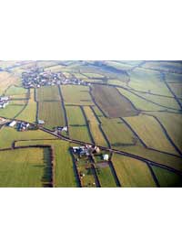
The Flatlands (Plains, Steppes, and Savannahs)
-
This are flat undulating lands that may have small hills no more that a few hundred feet. At sea level they are considered coastal plains.
However, they can be found at higher elevations a top plateaus or as large expanses of land in between other land features already
discussed. On our own planet we have the high plains that can be as high as 4,000 feet before approaching the foothills of the Rocky
Mountains. In drier regions they are known as savannahs and in others as steppes. In the beginning they are areas prized by nomadic peoples
for the abundant grasslands used to graze their herds upon. As civilizations move in they found the underlying soil to be prime for growing
crops of all kinds.
-
Inland Plains, Steppes, and Savannahs
-
Because of their smoothness, plains lands, if other conditions are favorable, are especially amenable to many human activities.
Thus it is not surprising that the majority the principal agricultural regions are found on plains. Large parts of the plains,
however, are hindered for human use by dryness, shortness of frost-free season, infertile soils, or poor drainage. Because of the
absence of major differences in elevation or exposure or of obstacles to the free movement of air masses, extensive plains usually
exhibit broad uniformity or gradual transition of climatic characteristics.
Answers.com
Many of these plains range between 1,000 feet up to 6,000 feet (including the high plains). Depending on wind direction and any
land forms blocking its flow, these plains can be well watered or arid. In either case, as stated above, they offer abundant grass
and fertile soil for those wishing to farm it.
-
High Plains
-
These are plains that can range between 2,500 feet and 6,000 feet. The High Plains are normally semiarid regions when mountainous
regions lie to the windward side of them, receiving between 10–20 in of precipitation annually. Shortgrasses and scrub vegetation
cover the region, with occasional buttes or other rocky outcrops. Agriculture in the forms of pastoralization and the growing of
crops is the primary economic activity in the region. The aridity of the region necessitates either dryland farming or some form
of irrigation.
-
Coastal Plains
-
An extensive, low-relief area that is bounded by the sea on one side and by some type of relatively high-relief landform on the
landward side. The region is may also be a rich source of various minerals due to the sea's deposits over time. Some of the best
building stone coming from the sandstone and limestone out crops found within this region.
Where a river enters the sea a delta is formed as the it changes course over centuries, creating many minor channels apart from
the main one and in the process large areas of salt marshes.
Close to the coast sea salt may be a hindrance to the raising crops but has no ill effect on the grazing livestock. Further inland
the land fertile and very good for all agricultural pursuits.
Land Commonly Used For Agricultural Activities
-
Croplands
-
Croplands are lands already under cultivation by civilized societies. Forty to sixty percent of these lands are normally arable cropland
growing grains, legumes, vegetables, etc. About ten percent of the land will have a small stand of trees. The remainder of the land will be
waste land or pasture.
-
Alpine Vegetation
-
Found only in mountains, above the treeline, and below the snowcap. For most of the year the ground is frozen and in the spring the
permafrost leaves the ground marshy. In the summer the area's meadows come into bloom and are often used as high pasture by local
civilizations, if the area is secure from dangerous bands of beasts, such as the gargun.
-
Woodlands
-
Areas where the tree canopy shades between 15% and 50% of the ground are woodlands. Woodlands are likely to contain mainly summergreen
deciduous trees growing in sometimes dense clumps, interspersed with open grassy areas. The open areas may be natural, fire induced, or the
result of human or animal intervention.
-
When there is no open lands to exploit the woodlands are usually the easiest and first lands to be exploited for agricultural use. The
small open grassy regions are used to start arable fields while trees are cleared for further arable lands and settlements. At first the
stumps are left in place within the fields and just plowed around until they can be removed at a later date. This enables more arable to be
brought into production in the meantime. Over a number of years the cleared land reverts to being called cropland.
-
Marshlands
-
Marshes occur where there is poor drainage. They are not necessarily impenetrable, but is likely to contain deep bogs, quicksand, etc, which
may not be visible. These lands can be turned into producible lands by improving their drainage and filling in of soft boggy areas. Marshes
are also good regions for the production of reeds for thatch, flax, and as a fishery.
-
Heathlands
-
Also called moors, heathlands are found mainly in windward, western margins where poor soils and high winds produce a unique environment.
Heathlands are mainly treeless, although a few stunted birches and willows can be found. The dominant vegetation is a dense layer of
sturdy, low-lying plants, rarely over 12-inches in height, heather being most common. Poor drainage creates bogs and peat moss in low lying
areas. Heathlands are commonly used as pasturelands by the locals.
-
Grasslands
-
Grasslands are commonly found on the various plains. When climatic conditions are right they are commonly converted into croplands.
Otherwise their primary purpose is as pasture.
Lands Commonly Found on Manors and/or Villas
Manor and/or villa lands are composed of the croplands, pastures, and woodlands. The land cleared for growing crops and the grazing of
livestock are known as the arable. When there is a labor shortage or a lack of seed some of this land will not be used and would
remain fallow. In addition to these three land types there are always the invariable wastes that include streams, ponds, rocky outcrops,
swamps, heaths, etc. All of these lands are used in the production of agricultural products or in the maintenance of the manor itself.
-
Croplands
-
This is the portion of the arable planted with crops. The principle crops are wheat, barley, rye, oats, vegetables, flax, and fruit. Of
course these are the common crop types for Hârn and most of the western regions of Northwestern Lýthia, other regions may have crop types
more conclusive with their environment and culture. How much of each crop is planted is determined by custom; with some areas favoring lower
risk, lower value crops. It is quite common to plant some acreage with what is known as winter crops, such as wheat and rye; these crops
are actually planted in the fall and hibernate through the winter and are ready for harvest in the spring.
-
The croplands are usually laid out in either two or three common fields. Each field is subdivided into furlongs which in turn are separated
from each other by a balk of unplowed turf. Furlongs follow the lay of the land to facilitate drainage, often laying at odd angles to each
other. The furlongs are sub-divided in narrow strips called selions. Each selion is assigned to a specific tenant. Therefore a tenant will
have strips throughout all of the fields instead of just one section of the field. This ensures that a tenant will have some good as well as
some bad land, and in most cases, an equal number of strips in crops and fallow. Furlongs are also commonly planted in the same crop, no
matter the wishes of an individual tenant; after all it is a communal field.
-
Freehold farmers are an exception to the above, they may have some strips in the common fields but will often have smaller separate fields
on the fringes of the open fields. The free holder can plant these separate fields as they wish.
-
The lord of the manor and/or villa may also choose to have all his land incorporated in the common fields, but will usually have a
significant part of it separated from them. Some of these separate lands will become orchards, others as vegetable plots, and the remainder
devoted to some form of cash crop or wheat for the lord's bread. These separate fields are known as the demesne.
-
Some of the freehold and demesne lands will also rotate between crops and fallow just as the common fields. However, due to their ability
to graze their animals on their own fields after harvest some of these lands may not lay fallow for a couple of years. This is because of
the focus a fertilizer on the land and its being able to remain viable longer.
-
Pastures
-
This is the portion of arable land used to graze livestock. Pastures can be permanent parcels of land set aside for grazing only and used
as cropland. This is especially in hilly terrain or where heaths are present; however, most pasture is cropland that was not planted or
fallow land. By grazing the community's livestock on the fallow weeds are kept down and the land get the benefit of their manure. The
fallow lands in the open fields and the common pastures are all communal property and managed by the community. Each tenant is allotted a
specific number of animals per the acreage they hold in tenancy.
-
Meadows
-
Within Hârn and Northwestern Lýthia meadows are considered part of the arable, although the crop they produce is hay and not for human
consumption. Most meadows are located along water ways where annual spring flooding sets the land up for the growth of a good hay crop.
Like the common fields the meadows are divided amongst the lord and the tenants; the tenants usually being chosen by lots.
-
Woodlands
-
Woodlands can make up ten to twenty percent of a manor's lands. These lands also include the wastes lands of the manor as mentioned above.
As a carefully managed resource they provide a place for swine to graze and a source for wild game, timber, firewood, berries, nuts, etc.
Return to top of page
|